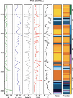
I am trying to predict the lithofacies, i.e. the rock type, from well log data, a project very similar to the one described in this tutorial.
A well log can be seen as a 1D curve tracking how a given property (e.g. gamma radiation, electrical resistivity, etc...) varies as a function of depth. The idea is to use these 1D arrays as the input features to train a Machine Learning model (e.g. SVM or Random Forest), to infer the facies at a given depth. For instance, in the image below:
- the first 5 tracks (GR to PE) are the well logs used as features
- while the last 2 tracks (Facies and Prediction) correspond to the true and predicted facies.
One of my colleague started using depth as a feature, thus obtaining much higher scores than when working with well logs only.
While this may make sense from a geological standpoint, as certain rock types are expected within a given depth range, I think that this will cause model overfitting [EDIT from June 1, 2022] I am concerned that doing so would put "too much constraint" on the model.
Is this explanation correct, or may depth (or position) be used as a feature to train a ML model?

